


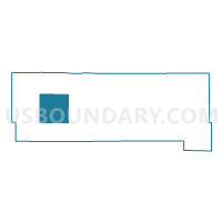
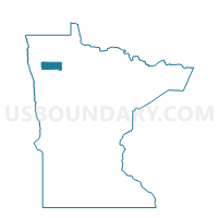
Sanders Twp. Voting District, Pennington County, Minnesota
About
Outline

Summary
| Unique Area Identifier | 603583 |
| Name | Sanders Twp. Voting District |
| County | Pennington County |
| State | Minnesota |
| Area (square miles) | 36.17 |
| Land Area (square miles) | 36.17 |
| Water Area (square miles) | 0.00 |
| % of Land Area | 100.00 |
| % of Water Area | 0.00 |
| Latitude of the Internal Point | 48.06422890 |
| Longtitude of the Internal Point | -96.30621430 |
Maps

Graphs
Select a template below for downloading or customizing gragh for Sanders Twp. Voting District, Pennington County, Minnesota


Neighbors
Neighoring Voting District (by Name) Neighboring Voting District on the Map
- Black River Twp. Voting District, Pennington County, MN
- Bray Twp. Voting District, Pennington County, MN
- Norden Twp. Voting District, Pennington County, MN
- North Twp. Voting District, Pennington County, MN
- Numedal Twp. Voting District, Pennington County, MN
- Polk Centre Twp. Voting District, Pennington County, MN
- Rocksbury Twp. West Voting District, Pennington County, MN
Top 10 Neighboring County Subdivision (by Population) Neighboring County Subdivision on the Map
- Rocksbury township, Pennington County, MN (1,211)
- North township, Pennington County, MN (708)
- Norden township, Pennington County, MN (379)
- Sanders township, Pennington County, MN (298)
- Numedal township, Pennington County, MN (90)
- Polk Centre township, Pennington County, MN (87)
- Black River township, Pennington County, MN (82)
- Bray township, Pennington County, MN (64)